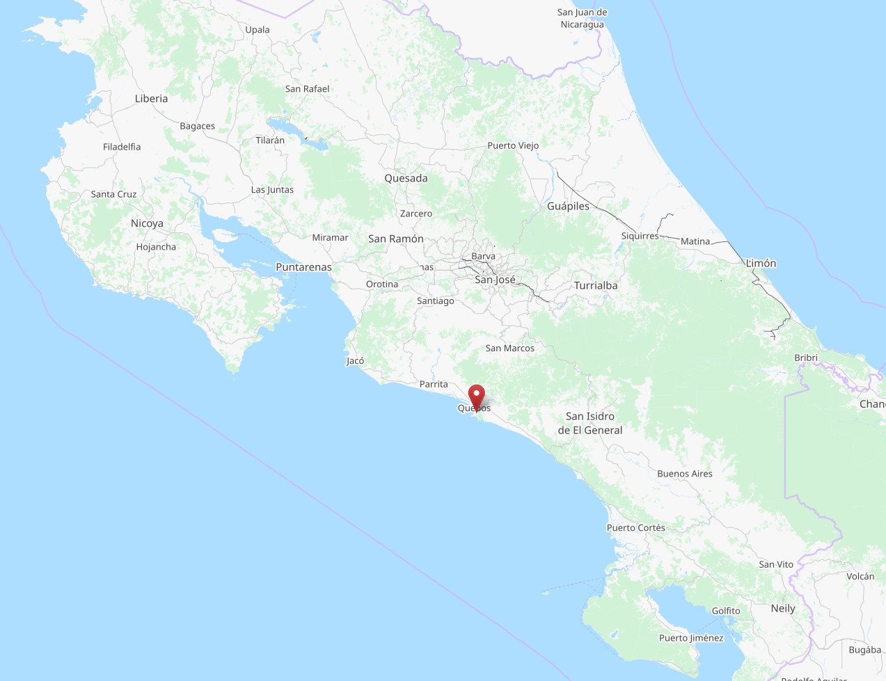
Best 50+ beaches in Puntarenas
Have you ever dreamed of walking on a paradisiacal beach in Costa Rica?
Dreaming of walking on a beach in Costa Rica can symbolize relaxation, escape, and a desire for a change of pace. The beach may represent a place of calmness and tranquility, and the act of walking suggests a desire for movement and progress. It could also indicate a need for self-reflection, as the sound of the waves and the beauty of the landscape may encourage introspection and contemplation. Alternatively, the dream could represent a desire for a tropical vacation, and a longing to escape from everyday stresses and routine. The location of Costa Rica may also hold significance, as it is known for its eco-tourism and emphasis on sustainability, suggesting a desire to connect with nature and embrace a more eco-friendly lifestyle.
So if you are planning a trip and need to start an surf adventure, you are exactly in the right place. Take a look at our top beaches in Puntarenas, and let yourself be inspired!
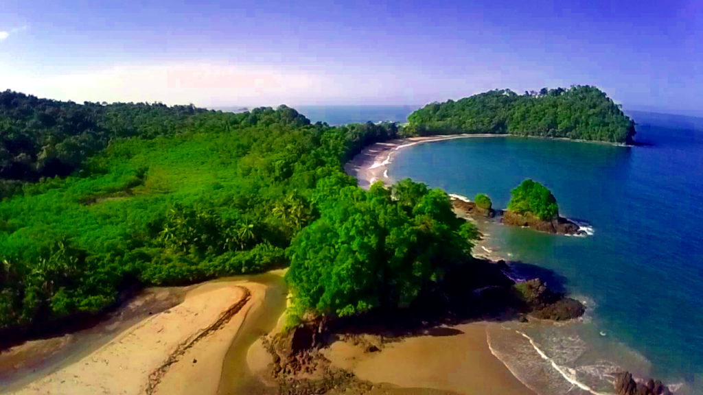
Playa Manuel Antonio (9°22’52.3″N 84°08’42.9″W)
Quepos walk 7 km by paved road to the entrance of Manuel Antonio National Park. Offer three exotic white sand beaches, campsites, showers, toilets, drinking water and dense vegetation, twelve islands, multiple inputs and forests are just some of the attractions of this interesting place. An absolute paradise.
Espadilla Beach (9°23’39.16″N 84°9’15.22″W)
Dark sand beach, beautiful, lush vegetation, reaching the edge of the beach. Its cliffs maintain the original vegetation and autumn in shallow water, we can see a large number of invertebrates, small fish and corals that are protected so that they can be used for scientific tourism must.
The temperature is high, between 25 ° and 27 ° C. remaining constant throughout the year. Its length is 3.6 km.
In the rainy season the weather is nice for tourists, as it usually rain freshening. Fishing is abundant and can be found, snapper, snook, mullet, pomfret, etc..
Playa Boca Vieja (9°25’55.03″N 84°10’4.30″W)
This beach is located in Quepos, so it is very popular among the residents of this city. It is located between the mouth of the river Paquita and its old mouth, from which it takes its name. It is very suitable for hiking and swimming. You can take boat trips on the river Paquita.
Playa Dominical (9°15’8.14″N 83°51’33.85″W)
Playa Dominical is located at the boundary between the Central Pacific and the South Pacific region. Ideal place for a beach holiday and surf. Dominical is surrounded by mountains and rivers with tropical forest with abundant water and is one of the most prosperous areas in tourism and real estate development as it takes less than three hours from San José by the new American highway. It is also just minutes from famous places like Manuel Antonio and Whale Park.
Playa Hermosa (9°34’21.81″N 84°35’53.41″W)
It is located in the province of Puntarenas, in the Canton of Garabito.
It has an area of 10 km, is dark sand. Its main attraction is its natural condition without development, the annual nesting sea turtles and the special high waves for surfing.
The beach is meant sun, sand, sea, hiking and surfing.
Playa Cabo Blanco and Balsitas (9°34’10.42″N 85°5’57.44″W)
Located in the province of Puntarenas, Puntarenas Canton. They are part of the Cabo Blanco Absolute Reserve, one of the most scenic areas of the Pacific coast. You enter through the sector Cabuya or Mal Pais.
Playa Cabo Blanco and Balsitas are the only extensive beaches that remain in state primary. A deep blue sea, vegetation dominated by evergreen species and reaches the edge of the coast, interesting geological formations, and lots of low tidal lagoons which are caught several species of marine organisms. The river forms a beautiful waterfall Balsitas to fall into the sea. The end or tip known as Cabo Blanco, consists of a mass of rocks, with various trails and vertical drops of 50 mt.
Playa intended to sun, sand, sea, hiking, nature lovers.
Playa Cocalito (9°41’21.96″N 85°0’50.45″W)
Located in the province of Puntarenas in Puntarenas Canton, 8 km south of Playa Tambor. To get there take the ferry of Paquera recommended as this is the shortest way.
Thick, dark sand, is located in a coastal area of vertical section, which forms a cliff with a beautiful waterfall.
Beach of sun, sand, sea, photography, snorkeling.
Beach Bodies
Located in the province of Puntarenas in Puntarenas Canton, 4 km from the town of Paquera. It is better to take the ferry of Paquera.
A safe beach, sand almost perfect with a wide bay and surrounded by coconut trees and jungle. Ideal for swimming and a comforting and peaceful landscape where you can admire the Turtle Islands.
Beach of sun, sand, sea, photography, snorkeling.
Caldera Beach and Estero de Mata de Limón
It is located approximately 20 km from Puntarenas.
The beach is 3.5 km long and is dark colored sand, has strong waves. In its vicinity is the Cerro Coyolar from which we can see the beautiful landscape. The estuary is very well preserved.
Main Pacific port. Around the beach there is a tropical dry forest to wet transition to a maximum height of 117 mt above sea level.
Note: Care should be taken to bath time both at sea and in the estuary at low tide by strong currents.
Playa Pógeres
It is located in the province of Puntarenas, in Garabito.
Form a beautiful cove, very inadequate for swimming and enjoying the surrounding maritime landscape usually is where many fishing boats anchored.
Playa Blanca
It is located in the province of Puntarenas, Garabito. It is part of Punta Leona.
Small beach 500 meters of white sand, gentle waves to the southeast. You sense the presence of beautiful cliffs, from where you can observe the penetration of water, agitated by the mass. It features lush vegetation along its coastline. Its crystal clear waters are ideal for diving in the vicinity of the rocks in the southeast. There is a rocky area that divides Punta Leona.
The beach is for: sun, sand, sea, water sports (surfing, windsurfing).
Its infrastructure and plant are of the highest quality.
Note: You must book in advance.
Palm Beach
Located in the Pacific Middle in Parrita.
Dark sand beach, strong surf, rectilinear features and offshore type, you should take precautions to swimmers during low tide.
It has an area of 6.7 km long, with vegetation, which provides good shade for the camper, has rich fishing.
Both the infrastructure and plant are poor except for an establishment that offers accommodation, restaurant and bar.
Playa Cabuya
Located in the province of Puntarenas in Puntarenas Canton Cóbano 13 kilometers.
The beach is located on a coastal rock platforms exposed variable, with intermediate segments of white sand in some places almost white. It has a length of 4 km leads to the absolute limit of Cabo Blanco. Type open sea with strong waves and deep water, so care must be taken during low tide, by the presence of exposed rock platforms. The richness of its vegetation and its potential in fresh water do have a great beauty.
Beach of sun, sand, sea, photography, snorkeling.
Playa Quizales
Located in the province of Puntarenas in Puntarenas Canton, 7 km south of Playa Tambor. We recommend taking the ferry Paquera.
It is a small beach 700 meters long. His gray sand and gentle waves of the water, are combined in a natural and quiet, ideal for walking and resting in the seashore.
Beach of sun, sand, sea, photography, snorkeling.
Playa Gigante
It is located in the province of Puntarenas in Puntarenas Canton in the Nicoya Peninsula. Take the ferry from Playa Naranjo that part of the city of Puntarenas.
It is a small beach surrounded by mountain slopes with abundant vegetation. It is of little waves and currency from its coast south and close to the Island of the Muerto.
Presents very pleasant conditions for rest and to take walks and rides to nearby places to observe the flora and fauna. From the nearby hills you can see a magnificent landscape of the Gulf of Nicoya.
Playa Puntarenas
National Excellence Resorts. Playa type straight, dark sand with a length of 12 km.
City that was generated from port activities and fishing.
Puntarenas presents an infrastructure and plant in great condition, also has a dock capable of receiving and supplying cruise. There is vegetation along the shoreline modality housing interspersed with trees.
Beach of sun, sand, sea, fishing from La Punta, where seawalls which in turn serve as lookouts and from which we observe the scenic beauty of the mouth of the Gulf of Nicoya. In the estuary can be made water sports and fishing.
Playa Tivives
Located on the eastern coast of the Gulf of Nicoya, southwest of Puntarenas, 8 km from Puerto Caldera.
Beach at the mouth of the Rio Jesus Maria. It has a size of 3.6 km, is dark sand. It has an area of mangrove declared Biological Reserve. Has vegetation along the coastline interspersed with housing mode, promontories in the southeast.
Tivives Beach offers not only sun and sea but other types of recreation such as fishing, boat trips through the canals of the mangrove, horseback riding, beach sports and for its strong waves ideal for surfing. On whether the entire beach at high risk.
Playa Agujas
It is located in the mid-Pacific.
Dark sand beach alternating with rocks allowing the formation of creeks at low tide, has a length of 0.7 km Presents great natural wealth that is used by campers.
Beach of sun, sand, sea, surf and fishing.
Note: Care should be taken to bath time by the presence of submerged rock and boulders.
Playa Esterillos, East, Central and West
Extensive beach of 6,800 mt, of great natural wealth all along the coast, rectilinear features, gray sand and open coast, with strong waves so the bather is recommended precautions. Presents mangroves to the east and center, small creeks and headlands to the west.
Tourist activities: walks along the edges of the mangroves, camping, watching from the headlands near the beach, is targeted especially for sun, sand, sea.
Services: accommodation, water, electricity, telephone.
Playa Palo Seco
Located in the Pacific Environment, Province of Puntarenas, Parrita Canton.
Playa slightly dark, half light predominating color and darker sands to extremes, has an area of 8,970 mt. Along its coastline has rich vegetation, dominated by palm, a lovely estuary and on the west the mouth of the Rio Pirris.
Recreational activities that may occur: swimming, surfing, beach games and sports. It is recommended not to bathe in the areas near the mouths of the strong waves and currents.
The infrastructure is poor, offers lodging, and food.
Playa Montezuma
Located in the province of Puntarenas in Puntarenas Canton. To visit we recommend taking the ferry to and follow the path Paquera Paquera-Cóbano-Cabuya-Montezuma.
Small beach of extreme beauty and exotic surroundings, where you can walk through dry forest natural environments, rocky areas that create small streams, waterfalls and ponds of great beauty.
Great for swimming and snorkeling dive rocky coves south of the population. At low tide the water comes into the coves bringing a vast array of marine life specimens, which you can enjoy walking along the beach simplemte.
Playa meant sun, sand, sea, photography, snorkeling.
Playa Tambor
It is located in the province of Puntarenas in Puntarenas Canton.
Bay surf and gently sloping sands and dark waters. Presents headlands at both ends, to have preserved its cliffs and mangrove vegetation of great importance. By presenting the bay provided no hazard to the bather.
Beach of sun, sand, sea, diving in the vicinity of headlands and rich fishing.
Its infrastructure and plant are of very good quality.
Note: You must book in advance.
Playa Naranjo
It is located in the province of Puntarenas in Puntarenas Canton in the Nicoya Peninsula. It is located very close to the ferry pier from Playa Naranjo that part of the city of Puntarenas.
It is a small beach that has little surf and coastal vegetation features. Because of its location, this beach is ideal for relaxing and admiring the seascape which highlights Caballo Island, located about five miles offshore.
From Naranjo can hike and horseback riding and mountain biking to other nearby attractions.
Doña Ana beach
Located in Boca Barranca River, 10 km from Puntarenas and has an area of approximately 700 mt.
Its coastline is irregular, with strong surf rocky parts. The beach is dark sand, with some parts where vegetation still exists. There are some cliffs that are a natural beauty. We found very attractive as the old rail tunnel called Tunel de Caballo. It has good infrastructure, beef ranches grill, restrooms, bathrooms, restaurant, lodging nearby.
Beach of sun, sand, sea, fishing and surfing great fashion at this beach. Care should be taken by heavy surf.
Playa Tarcoles
It is located in the province of Puntarenas, in the Canton of Garabito.
Beach where fishermen dock their boats, but is suitable for walking and observing the scenery.
Beach Blankets
It is located in the province of Puntarenas, in the Canton of Garabito. Part of Punta Leona Resort.
Gray sand beach, protected by beautiful promontories on either side, so it has a very gentle waves. Presents rich vegetation to the southern tip.
The beach is destined to sun, sand, beach sports, watersports and boat mooring.
NOTE: It is recommended to take precautions swimmer at low tide by the presence of stingrays.
Its infrastructure and plant are of superb quality.
Note: You must book in advance.
Playa Bejuco
Located in the South Pacific, Province of Puntarenas, Parrita Canton.
Dark sand beach. The coast has a very nice plant (coca, almond, etc..). Limits on the back, with Rio Bejuco and a mangrove area. The river mouth has playones for your enjoyment. They are part of the beauty of the villages and countryside landscapes along the road.
Intended Beach: sun, sand, sea, fishing and beach sports. Sea warm throughout the year without atmospheric disturbances.
Good infrastructure, provides a small hotel on the beach type.
Playa Damas
Located in the Pacific East (Quepos), Province of Puntarenas, Parrita Canton.
Rectilinear beach with large mudflats, sand dark, with a length of 6.9 km, has a mangrove estuary intercoms with Palo Seco, only accessible through the estuary in small boats. The estuary has very good characteristics for tourist recreation, boating, surfing, fishing, sailing, etc..
Playa Savegre
It is located in the province of Puntarenas in the Canton de Osa.
Presents an area of ??approximately 12 km, stretching from the mouth of the Rio Naranjo which presents scenic attractions, particularly the Island and Punta Mogote Serrucho to Savegre River. Dark sand beach, straight type and open water.
They may engage in sun, sand, sea, beach sports, hiking, wildlife watching and fishing, especially in the mouths.
Playa Uvita
Located in the province of Puntarenas, in the Canton of Osa, 16 miles south of Dominical. It is within the Ballena Marine National Park.
Curvilinear beach that extends about 4 miles between Punta Uvita and Playa Pedregoza, at the southern end. The sand is grayish, has little vegetation except for a row of coconut trees is located in the southern sector. Has good conditions for swimming, as the rocky outcrop (Punta Uvita) acts as a natural breakwater.
Beach of sun, sand, sea, good fishing, the surrounding landscape is an attraction.
Playa Piñuelas
Located in the province of Puntarenas, in the Canton of Osa.
Small beach, curvilinear moderate average slope, light gray colored sands. It has an area of 1,300 m in length. Bay is a small little waves, suitable for swimmers and for anchoring boats. Their resources are very significant scenic, countryside villages and landscapes along the road.
Beach activities aimed at sun, beach, ocean, fishing and diving.
Playa Garza (Boca Brava)
It is located in the province of Puntarenas, in the Canton of Osa, south of Boca Brava, 21 km from Palmar Norte.
Beach 6.5 km long, south side is called Boca Brava Beach. The beach is wide and has a very poor vegetation cover.
Suitable for walking but not for swimming. Its waves are great for professional surfing.
Playa Llorona
Located in the province of Puntarenas, Osa Canton. It is part of the Corcovado National Park Sirena section. Reservation Park Ranked in Puerto Jimenez and Sirena station reported. It goes up to Carate and from there is walking.
Beautiful scenic beach surrounded by undisturbed tropical forests. Bordered on the northwest and southwest Punta Llorona with the Corcovado River estuary. To lead to the sea, a river cascades Llorona is indescribably beautiful. A mangrove swamp is located on river estuaries Llorona, Corcovado and Sirena further south.
Form a single coastline with beach and Playa Sirena Corcovado, separated only by the river and Sirena Corcovado, Rio Claro being Punta Rio Claro and Punta Salsipuedes ends farther south.
Playa intended for hiking, nature lovers.
Playa Matapalo (Osa)
Located in the province of Puntarenas, Osa Canton. At the southern tip of the Osa Peninsula. The reference point is where is located the Cabo Matapalo.
In this area there are several coves and beaches of great natural beauty, because their environment is characterized by having very wet woodlands, where live several species of birds, monkeys and other animals.
There are waterfalls and other resources ideal for observing this rich biodiversity. Beaches as Matapalo, “Backwash”and Pan Dulce are preferred by surfers, and which have excellent conditions for this sport.
Playa Platanares and Puntarenitas
It is located in the South Pacific, Osa Peninsula.
Very wide and pleasant beach, extending south from the area known as Punta Arenitas. With moderate waves, scenic wealth attended by banks, cliffs and mangrove river mouth Platanares.
The main attractions are related to the presence of natural sites, especially forests, rivers, fishing, adventure, investigation and observation of nature, especially the birds, besides activities of sea, sun and sand.
Cacao Beach
It is located in the province of Puntarenas, 2 km from Golfito.
It is a brown sandy beach. Not have waves, is not very deep, making it an excellent choice for swimming or boating
Playa Matapalo
It is located in the province of Puntarenas, Osa Canton.
This beach is adjacent to Playa Savegre and extends five miles between the mouth of the Rio Savegre and New Hatillo. It’s of the kind open sea, straight, and strong waves. The sand has a dark gray color. Has abundant vegetation, consisting mainly of almond and coconut.
Note: The bather must take precautions to bath time for the characteristic of the open sea.
Playa Dominicalito
It is located in the province of Puntarenas, Osa Canton.
Curvilinear type beach that extends from the area known as Rocas Amancio, to Punta Dominical, with an extension of just over 1 km. The sand is gray, has good quality scenic attractions. The beach is suitable for swimming for the characteristic of gentle waves.
The activities that can be performed: fishing, diving, boat rides, water sports and beach.
Arco Beach
Located within walking distance of Playa Uvita, covers close to 500 mt. Its name comes from the presence of a cave or rock cavern arched. The beach area has little supralittoral. Presents coastal vegetation in their environment, villages and countryside scenery along the road. There is abundant fishing and boat trips to nearby places like Isla Ballena.
Playa Ventanas
Acquires the name of the form they have acquired the rocks. It has an area of 500 meters in length. Its sands are grayish and curvaceous coast, forming a cove that for this condition favors the swiming. Tips, cliffs, canals, estuaries and islands, virgin forest areas and large coastal vegetation, so beautiful scenic form.
Playa Ventanas is focused especially for scientific tourism, photography, observation. You can perform activities such as surfing, bushwalking, fishing, diving in the beaches surrounding the tip.
Drake Bay Beach
Located in the province of Puntarenas, Osa Canton. The can also be done by boat from Sierpe.
This beach is made ??up of rocky areas and coves of great beauty. Due to frequent rainfall has a tropical wet forest of great interest for its rich biodiversity.
You can hike or horseback ride to nearby attractive.
Playa Madrigal
Located on the Osa Peninsula, Puntarenas Province, Osa Canton. The road from Puerto Jimenez Carate end.
Beach next to Corcovado National Park (sector La Leona). Known as the delight of ecotourists, and one of its most popular destimos. It has great scenic beauty, as the beach is kept almost unchanged. It is a very quiet place.
Beach intended to sun, sand, sea, hiking, horseback riding, nature lovers.
Sombrero Beach
Located in the province of Puntarenas, Osa Canton. It is 15 km from Puerto Jimenez and 30 km from Corcovado National Park (Sirena sector).
Beautiful scenic beach, bordered to the northeast and southwest hat tip to Punta Matapalito (near Cabo Matapalo, the southern tip of the Osa Peninsula). Beach surrounded by rainforest, crossed only by the way to Carate. It has a lush and peaceful, is special to relax.
Intended Beach: sun, sand, sea.
Playa Blanca (Jimenez)
It is located in the province of Puntarenas, in the Canton de Osa, 2 km from La Palma.
A beach of pale sand and moderate waves. It is frequented by residents of La Palma. It is a peaceful place of great scenic beauty, it is located within the Golfo Dulce which is surrounded by mountains with evergreen forests. While sunbathing you can watch colorful seabird groups planning in heaven.
Playa Zancudo
Located on the Golfo Dulce, in the Pacific Ocean, near Golfito, South Zone.
If you want to escape the routine and spend a few days away from the madding crowd, Playa Zancudo, with its sea,sun and vegetation surrounding, is definitely your ideal destination. Playa Zancudo awaits hidden to give the passivity and unchanging beauty and calm blue waters, its gray sand beach, which extends about 200 m at low tide.
Playa Baru
It is located in the mid-Pacific.
Dark sand beach, gently sloping and gentle waves, with a length of 3,140 mt. Its main attraction is the lush vegetation and freshwater potential, has a well developed mangrove habitat that serves the most varied species as a complement to life itself sea and rivers. The region is an area totally controlled anidazión turtle.
Recommended for tourism and scientific observation. For swimmers, take precautions toward the southeast in the mouth of the Rio Baru.
Hermosa Beach (Osa)
It is located in the province of Puntarenas, Osa Canton, 14 miles south of Dominical.
Access to this, from Punta Dominical, is very attractive, because its path is in a mountainous area from which dominates its rocky coast and irregular. It is located about 8 km from the reference point and its length is about 6 km. At its southern end has a rocky interspersed with sand, known as Punta Uvita. It rectilinear and slightly curved in its southern part. Its sands are gray.
Beach of sun, sand, sea and especially fishing in river mouths and Uvita Higuerón.
Playa Ballena
It is located in the province of Puntarenas, Osa Canton.
Wide beach, with an area of 3 km. Low swell and moderate slope. Suitable for the bather. Its sands are colored gray. Excels the presence of highly attractive wooded areas and the availability of land behind the beach. Presents estuaries on both ends. Fishing and diving in summer are potential activities of the place. Beachfront is located the island of the same name suitable for diving.
Playa Ballena National Marine Park was declared a whale, for the protection of the humpback whale.
Playa Tortuga
It is located in the province of Puntarenas, Osa Canton, 15 miles from Ciudad Cortés.
It is located between the mouth of the Balsa River and Boca de Coronado. It is approximately 2.5 km long, its sands are gray. Despite being open sea, the coast offers no strong waves, which favors the bathing. At its western end there is a mountain that separates out this beach of Playa Ventanas. This is very steep and, from there, with stunning panoramic views very extensive and valuable tourist.
The Boca de Coronado, mangrove and its amplitude is an ideal place for boating and fishing. The beach is suitable for surfing and sailing.
Playa San Josecito
Located in the province of Puntarenas, Osa Canton. It is 13 km north of Drake Bay, 6 km from Corcovado National Park to the south (San Pedrillo sector). Access is by boat from Sierpe or Drake Bay.
The beach has gentle waves, due to small islands that serve as natural breakwaters. At low tide you can enjoy the natural pools that form. The ends of the beach have rock formations, Punta San Jose is in the far north.
The beach is a beautiful scenic view of its proximity to Corcovado National Park. Remains virtually unchanged.
Intended Beach: sun, sand, sea, camping, hiking, sea kayaking and nature lovers. It is perfect for swimming and diving.
Playa Carate
Located on the Osa Peninsula, Puntarenas Province, Canton of Osa. Here ends the road from Puerto Jimenez.
Black sand beach of volcanic origin. The landscape of the area is of great scenic beauty, so close it is the Corcovado National Park. Is its virgin forests abundant wildlife, and the beach is an important nesting site for the Green Sea Turtle.
Beach intended to sun, sand, sea, hiking, horseback riding, nature lovers.
Playa Tamales
Located in the province of Puntarenas, Osa Canton. Located south of Puerto Jimenez, Matapalo way.
It is a long sandy crescent shaped, with rocky coastline south. In its middle flows the River Tamales. Presents mild to moderate swell, depending on where it is located.
It has coastal vegetation where you can observe birds.
Playa San Josecito (Golfito)
Located in the province of Puntarenas, Golfito Canton. Access is possible only by boat from Golfito or Puerto Jimenez. Borders the Piedras Blancas National Park.
Beautiful scenic beach and calm waters, bay type. Its vegetation is almost unchanged. The ends of the beach have rock formations, Punta Adela is in the northwest and the southwest Punta Gallardo.
Intended Beach: sun, sand, sea, hiking, camping, sea kayaking, fishing, scuba diving, swimming and nature lovers.
Playa Pavones
It has an area of 1.5 km, light brown sand, is a semi-open bay, open front wave from southwest to northeast. Presents headlands in the south. Playa Pavones is known worldwide for surfers, is considered the number one for having the world’s longest wave of his good form and fast, you should take precautions during low tide. It is located 800 km from San José to 8 hours by car, you can rent boat in Puerto Golfito. Vegetation somewhat altered, you can camp.
Herradura beach
Located in Puntarenas, near Jaco. It’s a fine brown sand beach and crystal clear water, with mild to moderate swell, ideal for bathers. From this sunny beach over 2 kilometers long can be seen the imposing Herradura Island, tropical forest cover, natural refuge of different species of seabirds. Playa Herradura has been recognized Blue Flag and its coastline, likea horseshoe, is surrounded by lush vegetation.
Jaco beach
Jaco is a bustling town with one of the most popular beaches of Costa Rica. Located in the province of Puntarenas in the center of the Pacific coast and with the reputation of being a ‘party beach’ with an excellent nightlife. However, the fun here is casual and relaxed and very friendly inhabitants. Caters mainly to a majority of foreign tourists who want to enjoy a more relaxed lifestyle. Jaco has a nice beach and you will find accommodations to suit all budgets and besides being a good choice to eat as there are many restaurants and a good number of cafes and shops. There are too many people on the tour operators that arrange everything from horseback riding on the beach to excellent fishing off the beach and kayak at sea.
The main attraction of this town is the fantastic surfing here as the waves are consistently big and the breaks are very good. Annually took place a tournament in Playa Hermosa near this beach attracts a large number of surfers from around the world.
Playa Jaco is about 3 km long and is easily reached by taking Route 27 and is less than 90 minutes from San Jose.
We hope your dream comes true soon!